Wansford Station
Turn off the A1 at the Stibbington flyover, which is 1 mile south of the A1 / A47 interchange and 4 miles north of the end of the A1(M). Look for the large brown "Nene Valley Railway" signs on both the A1 and A47.
Note: Avoid Wansford village on the opposite side of the A1.
Please note that there are yellow lines along the full length of the Old Great North Road - please observe the parking regulations. We do not own the land opposite the station and do not recommend parking there as the land is owned by Highways and subject to the yellow line restrictions. Please park considerately in our car park to help maximise the space available.
Station Facilities include: Toilets, Cafe, Gift Shop, Charity Shop, Second Hand Book Shop, Railwayana, 92 Squadron Shop, Miniature Railway, and Model Railway, Viewing Gallery in the work sheds.
Click to view our 360 tour of Wansford Station:

Free Car Park
Sat Nav: PE8 6LR
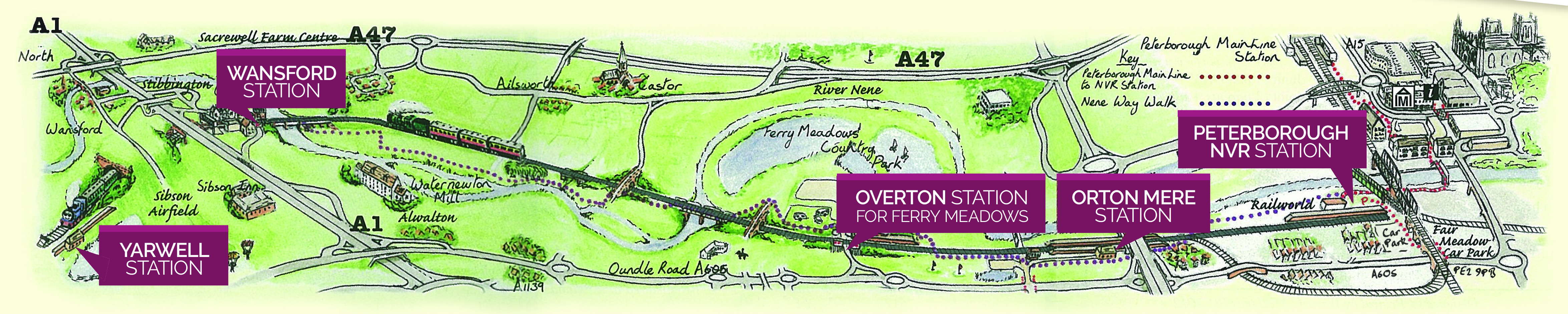
Yarwell Junction Station
1 mile west of Wansford Station. Yarwell Junction station is situated approximately 25 minutes walk from the villages of Yarwell and Nassington and only 10 minutes from the Nene Way.
From Yarwell, follow the signs for the Nene Way which goes through the Yarwell Mill caravan site and over the lock. The route to Yarwell Station is then signposted from the Nene Way, crossing over the backwater via a bridge. There is another signpost at the turn-off for the station.
From Nassington, pick up the Nene Way opposite the Black Horse public house. Follow the Nene Way until the signpost for Yarwell Station directs you over the bridge over the backwater, and then continue as above.
Yarwell is an ideal tranquil spot for a picnic - sit in our tended gardens and enjoy the view.
Please note there are no toilet facilities.
Parking: Yarwell Junction station is only accessible on foot or by train - there is no vehicular access.
Overton Station (for Ferry Meadows)
2 miles west of Peterborough along the A605 Oundle Road. Buses are available from Queensgate Bus Station (telephone 0870 608 2608).
Parking: Parking is available inside the Nene Country Park (charges apply). See here for further details:
Sat Nav: PE2 5UU
Orton Mere Station
1 mile west of Peterborough along the A605 Oundle Road. Buses are available from Queensgate Bus Station (telephone 0870 608 2608).
Parking: Charges apply. See here for further details: https://www.nenepark.org.uk/news/new-parking-charges-at-orton-mere-and-thorpe-wood
Sat Nav: PE2 7DA
Peterborough (Nene Valley) Station
Next to Railworld. Signposted from the A605 Oundle Road next to the railway bridge.
Parking: Parking available at Pleasure Fair Meadow Car Park (charges apply). See here for further details:
Sat Nav: PE2 9NR
From Peterborough Mainline Station (on foot)
Turn right out of the mainline station and then go over the pedestrian crossing and up to the dual carriageway.
Turn right, walk under the footbridge and continue to the subway. Go through the subway and, shortly after, turn right through another (smaller) subway, then turn left up the ramp to meet the dual carriageway again.
Continue alongside the dual carriageway until you reach a side road called Viersen Platz. Turn into this road and continue along it, keeping the ASDA car park and store to your left. Ignore the signpost directing you to turn right down a footpath towards the river - that's the long route - instead carry on, with ASDA still on your left, until you come to a large blue footbridge over the river. This footbridge has steps and is not suitable for wheelchairs. Wheelchair users can cross the river via the town river bridge on Bridge Street.
Cross the footbridge, follow the footpath alongside the river, and you will soon come to twin railway bridges. Pass under these two bridges and then under another very low one a little further on. Next, take the left fork up to the Railworld frontage and the short footpath from there to the NVR station.
From Queensgate Bus Station
Bus passengers should alight at Queensgate Bus Station and head for the mainline railway station.
Once across the dual carriageway, using the footbridge, the above instructions should be followed from "Turn right, walk under the footbridge...".
NOTE: For those who have used the alternative route on the NORTH side of the river and crossed using the RAILWORLD bridge, please be aware that Railworld have now closed this bridge to public access. PLEASE USE THE BRIDGE BY ASDA.
Follow this link to download a map to aid your journey. This map has been kindly supplied by our colleagues at Railworld and is hand drawn by one of their volunteers called Martyn Hanks.
Peterborough Main Line to Railword/PNV
If you would like to view more of Martyn's lovely drawings, please follow this link;